


|
|||
|
Discover the origin of the ‘Aquae Patavinae’ and the history of the Euganean thermal area...
|
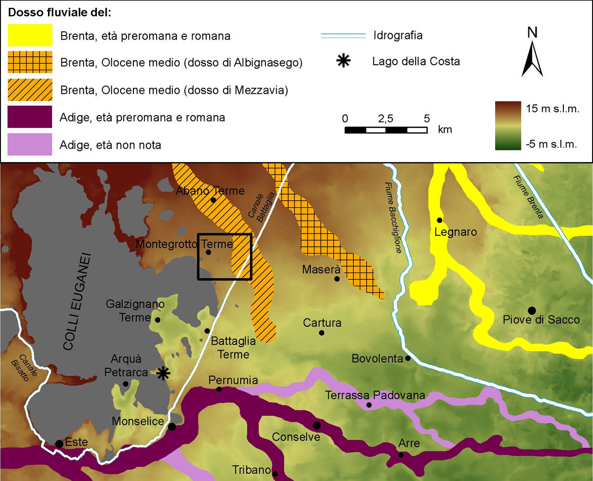
GeomorphologyThe geoarchaeological researchThe peculiarity of Montegrotto Terme and its territory lies in its location within the Euganean thermal area. The study of this unique natural context has been tackled using research methods peculiar to geomorphology, paleobotany, pedology and hydrology. The reconstruction of the ancient landscape and its transformations has been approached in a multidisciplinary way, in order to recognize the complex dynamics that, since ancient times, have bound men to the environment in which they lived. Geomorphology of the flatlandThe plain which stretches to the foot of the Euganean Hills is the result of the sedimentary activity of the rivers Brenta and Adige. During the last 20.000 years, the area located north-east of the hills has been crossed at various times by the Brenta. The Adige has always been active south of the hills; northwards, it has never gone beyond the dip followed at present day by the Canale Cagnola – Canale di Bovolenta.
The most distinctive form of the plain is the so-called fluvial ridge: high up to 2-3 m above the surrounding plain, it is hundreds of metres wide and can run even for dozen of kilometres moving downstream. A ridge forms as a result of the deposition of sandy and muddy sediments both within and near the watercourse during floods. This phenomenon causes the gradual uplift of the river bed above the plain; as a consequence, the river becomes “raised”. Each ridge matches the direction followed by the river for a certain time lapse, which could be either of few centuries or of thousands years. In the tangled network of ridges that cleaves through this portion of the Venetian plain, it is possible to recognize some of the main courses followed by the rivers Adige and Brenta in protohistoric and Roman age. The “Mezzavia ridge” matches the course of the Brenta: approximately 6.000 years ago this river flowed near Montegrotto, depositing its sediments as far as the present-day built-up area of the town. The minor depositing activity of the rivers Brenta and Adige in the belt of alluvial plain located at the back of the Euganean Hills has implied the formation of low-lying areas of land. The wide depressions of Arquà Petrarca and Galzignano are clearly recognizable in the model of digital elevation which lies at the base of the geo-morphologic map. The depression of Montegrotto spreads out as far as the slopes of Monte Alto and Monte Castello and covers the west portion of the present-day urban centre.  Il lago della Costa ad Arquà Petrarca The depression of Montegrotto is currently restrained by a grid of artificial drainage, which pivots on Scolo Rialto, Scolo Cannelletta and Rio Spinoso; without this grid also this area would be subject to swamping and water stagnation. The water inlet depend not only on the flowing of meteoric waters but also on the surfacing of the thermal aquifer. The archaeological excavation works carried out in Montegrotto Terme between the end of the 19th century and the first half of the 20th century related the presence of lacustrine deposits between Monte Castello and the side of the Euganean Hills, in a wide area today occupied only by a little water basin – highly artificial and named after the fascinating toponym of “Torre al Lago”. Scholars are currently studying the surface sediments of the depression of Montegrotto, with the aim of verifying the hypothetical presence of a lake or marshland in pre-protohistoric and Roman age. |
||
|
|
|||