Hydrologic aspects
Hydrologic aspects of the Euganean thermal area
 The Euganean thermal area is one of the most important thermal centres in North Italy and extends over a surface of 36 kmq. Since the 20th century, thermal waters have been intensively extracted from the subsoil by means of wells, for therapeutic purposes. Approximately 100 mining concessions are active in the area, and the drilled wells are more than 450. At present day, the active wells are more or less 250, and the related extraction of thermal fluids is assessable at about 15 million m3 per year. After 1950, owing to the increase in the demand of thermal waters, the level of the thermal aquifer deepened and thermal springs disappeared. Following a regulation of the extraction capacity, the aquifer level has regained height, being now virtually steady. Water extraction occurs within the rocky substrate, located at a depth which varies from a few metres (Montegrotto Terme) to 200 m (Abano Terme).
Thermal water temperature can vary from 65° C to 86° C; moreover, the chemical prevalence of sodium chloride and the overall salinity of these fluids, that can even hit 6 g/l, attest the presence of a deep hydrothermal circulation. The analyses of hydrogen isotopes (3H) reveal removal times that exceed 60 years, and probably are in the order of some thousands of years – as some isotopic analyses of carbon (14C) have also shown. The theory of Euganean fluids coming from high depth and with long removal times seems to be supported by recent isotopic measures taken in some calcareous sinters from Abano Terme (Colle Montirone), which reveal extremely low uranium levels and a prominent 234U/238U ratio.
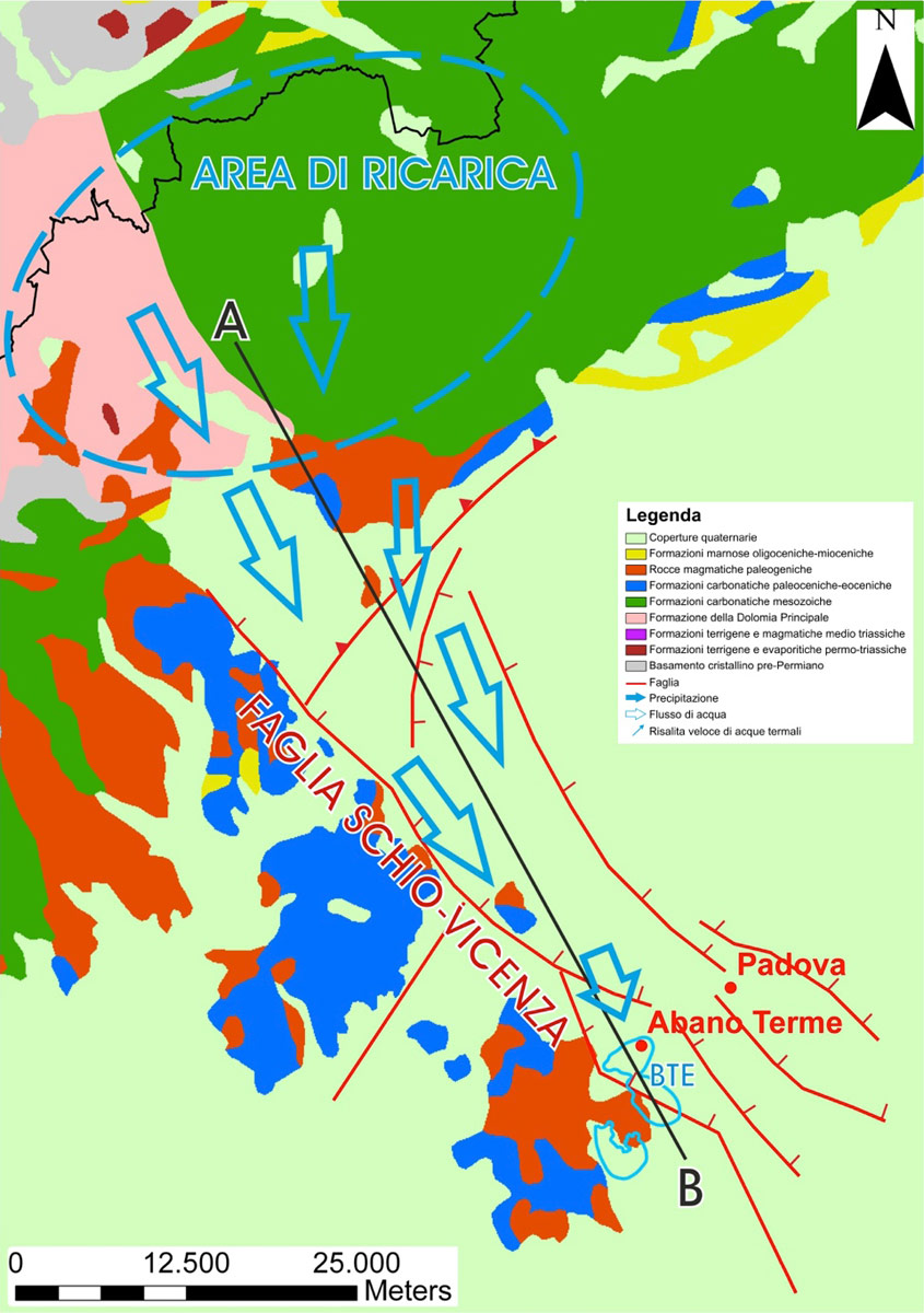
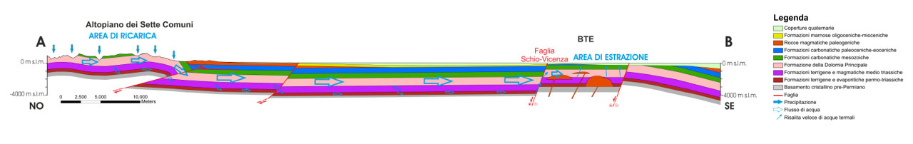
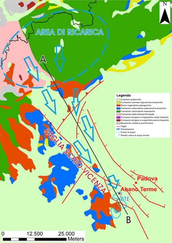
The recharge area of this system could be located 80-100 km north of the Euganean thermal basin, in the Prealps north of Schio (Vicenza district, central-northern Veneto). Isotopic analyses of oxygen (δ18O) indicate that thermal waters derive from rainwater precipitations occurred at an height of almost 1.5 km, which corresponds to the median altitude of the upland area. Rainwater seeps and probably reaches a depth of nearly 3 km, warming up under the effect of the geothermal gradient (30°C/km).

This water flows from the recharge area towards the south as a consequence of the fracturing of reservoir rocks, phenomenon that can be connected to the activity of the Schio-Vicenza fault – which acts as primary circulation structure for Euganean thermal waters. In the Euganean basin, these waters meet in the depths some fractures kept open by a geological formation linked to the Schio-Vicenza fault; then, through these rifts, water rises again and gets to the primary thermal reservoir, mainly consisting of limestone and dolomite rocks dating back to Mesozoic age (approximately 251 – 65 million years ago). From here, through other fractures, water finally reaches the outer layer.